

Come feel the mist of Oregon waterfalls on your face!
Spring showers don’t just bring May flowers in Oregon. They, along snow pack melt, supply Oregon scenic rivers the water needed to create our wildly beautiful and renowned waterfalls and spectacular wildflowers
And it’s certainly not too early to start planning your Oregon Bed and Breakfast vacation that should involve chasing waterfalls and wildflowers.
Oregon has more than 238 waterfalls across the state (and 1,000+ according to the Northwest Waterfalls Survey). We’ve come up with a list of 66 must-see waterfalls (it’s really more like 80 since we grouped some together).
OREGON CASCADE WATERFALLS
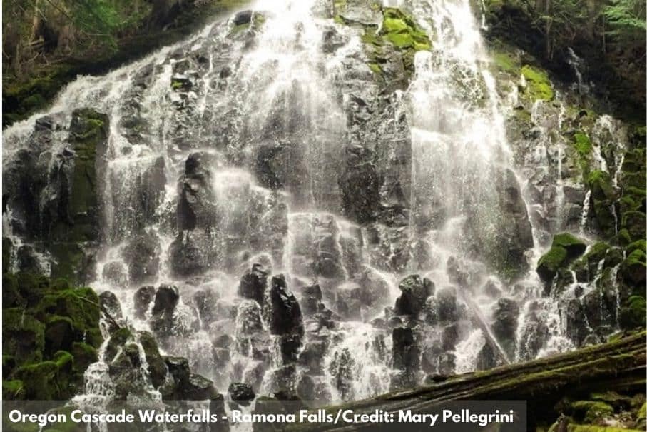
Ramona Falls (W17): This shaded waterfall is in a forest along the Pacific Crest Trail on the upper Sandy River — on the west side of Mount Hood. The falls are about 120 feet tall, consisting of a wall of cascades.
Tamanawas Falls (W18): Bring your binoculars and prepare to see a lot of birds and a stunning waterfall! The falls are AMAZING at 100 feet high and 40 feet wide. The trailhead footbridge is the midpoint of a 8-mile stretch of the East Fork of the Hood River hosting nesting Harlequin Ducks. Belted Kingfisher are common but it’s the songbirds you’re likely to remember long after they’ve sung their tunes.
Little Zig Zag River Falls (W19): One of Oregon’s hidden gems. A picturesque stream leads to a photogenic waterfall on this family-friendly trail; complete with a picnic table at the very start. It couldn’t be more perfect.
Yocum Falls (W20): This waterfall is right in the heart of the Mount Hood National Forest. It sits in Zigzag canyon with many waterfalls, including Little Zigzag River Falls and Ramona Falls.
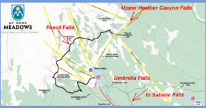
Pencil Falls (W21): This glacier-fed waterfall is in the alpine area of Mount Hood Meadows. A small path leads to a great viewing.
Upper Heather Canyon Falls (W22): Where the Timberline Trail crosses Heather Creek, is thought to be one of the most scenic areas of Mount Hood. In Heather Canyon a series of waterfalls tumbles beneath this trail.
Umbrella Falls (W23): This popular and family-friendly waterfall is accessible from scenic hiking trails.
White River Falls (W33): The waterfall is the main focus of the White River Falls State Park and for good reason — the scenic White River plunges 90-feet from a basalt shelf.
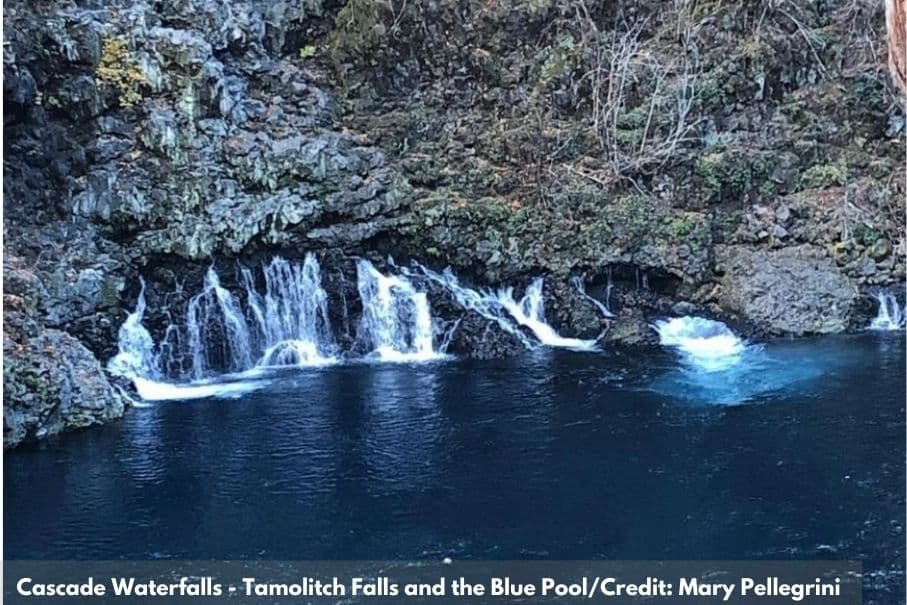
Tamolitch Falls (W45): Follow the McKenzie river through the old growth forest to Tamolitch Falls, which flows into a lava formed Blue Pool, renowned for its iridescent blue coloring.
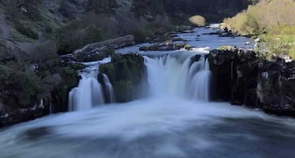
Sahalie Falls (W46): Sahalie Falls, is the first and tallest of three waterfalls on the roaring McKenzie River. It plunges about 100 feet over a naturally formed lava dam.
Koosah Falls (W47): Koosah Falls, aka Middle Falls, is the second of the three major waterfalls of the McKenzie River, in the center of the Willamette National Forest. The waterfall plunges into a pool, south of Santiam Pass, a renowned 4,817-foot mountain pass in the Cascade Range.
CENTRAL AND EASTERN OREGON WATERFALLS
Hurricane Creek Falls (W24): Hurricane Creek Falls are located along granite and limestone cliffs and an incredible amount of wildflowers along the Hurricane Creek Trailhead at Wallowa-Whitman National Forest.
Falls Creek Falls (W25): This is one of the prettiest waterfalls in the Pacific Northwest!
BC Creek Falls (W26): Located near Wallowa State Park, BC Creek Falls (W26) lies within the Chief Joseph Mountain Trail, approximately an 8-mile out-and-back trail near Joseph. In less than 3-miles on the trail you’ll find two rivers and Wallowa Lake views, in addition to the falls.
Wallowa Falls (W27): Take Chief Joseph Trail to Wallowa Falls (and BC Falls – just a few miles away). Wallowa falls seems more like a long rapid but its location, nested in a deep gorge is beautiful.
John Day River (W37): This is the longest un-dammed river in Oregon. The section between Service Creek and Tumwater Falls flows through a colorful canyons and beautiful terrain.
Steelhead Falls (W48): Formed a few million years ago, this Oregon waterfall is lined by colorful 25-foot cliffs. The fall drops into a deep canyon.
Tumalo Falls (W53): Tumalo Falls is both the tallest, 89 feet, and most impressive waterfall along Tumalo Creek – as well as one of the most popular outdoor destinations in the vicinity of Bend.
Benham Falls (W58): These are the largest falls on the upper Deschutes River. Unlike the other falls the area, Benham Falls is not related to a lava flow. It is a free-form cascade in its own right.
Fall River Falls (W59): A trail passes by historic cabin ruins and parallels the Fall River all the way to the falls.
McKay Crossing Falls (W60): This 23-foot waterfall plunges into a small canyon with several picture-ready viewpoints.
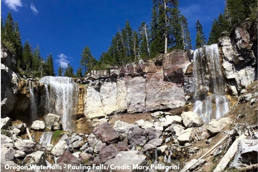
Paulina Creek Falls (W61): This waterfall is known for its side-by-side drop of 80-feet that surrounds a small island at the edge of the cliff.
COLUMBIA GORGE WATERFALLS
Bridal Veil (W8): Hidden beneath the Historic Columbia River Highway, this small two-tiered waterfall is easy to reach. Make sure to check out the romantic messages carved into the handrails of the viewpoint.
Wiesendanger Falls (W9): Named after Forest Service Ranger, Albert Wiesendanger, the 55-foot falls is on Multnomah Creek
Ponytail Falls (W10): Ponytail Falls, also known as Upper Horsetail Falls, is on Horsetail Creek just above Horsetail Falls. This is one of the more popular waterfalls for professional photographers, for stunning pictures looking out from behind the falls. See a ‘behind’ shot.
Elowah Falls (W11): Elowah Falls drops 289 feet into an amphitheater of lava flows of millions of years ago.
Wahclella Falls (W12): OregonHikers.org describes this fall as one of the more interesting falls in the Columbia River Gorge. It runs along Tanner Creek and features two drops.
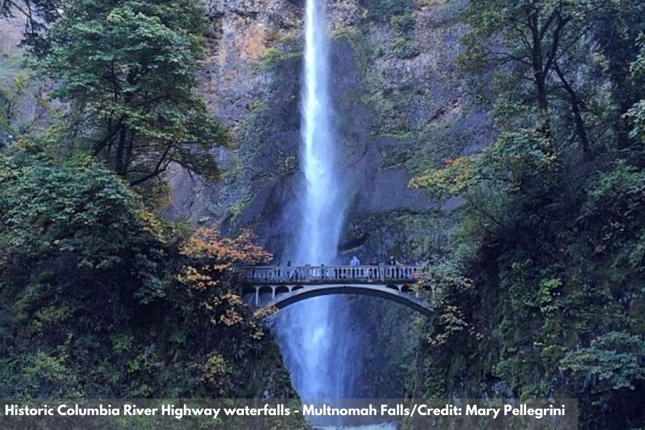
Historic Columbia River Highway waterfalls — including Multnomah Falls, Horsetail Falls, Latourell Falls, and Wahkeena Falls; W14): You can tour the waterfalls that make up the Columbia River Gorge by car or on foot, but you won’t have the full-on spectacular experience unless you do both. Whatever you do, make sure to save time to see Multnomah Falls. It is the most visited natural recreation site in the Pacific Northwest and more than 2 million visitors come each year to take in its view.
Ecola Falls (W15): Ecola Falls is the last major of the falls as you travel upstream on the Larch Mountain Trail. What does ecola mean? It’s the Chinook word for whale.
OREGON COAST RANGE
Bridge Creek Falls (W5): This three tier fall has a 35-ft drop and is right near Highway 6 by the Footbridge Trailhead.
Fern Rock Falls (W6): An understated and beautiful waterfall along Highway 6.
University Falls (W7): Located within an area that was devastated by one of the worst forest fires in Oregon’s history, this forest was rehabilitated, trees were planted (more than 70 million!) and the Tillamook State Forest began. University Falls is a 55-ft fall over a wall of basalt.
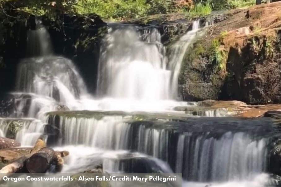
Green Peak Falls (W41): This is the second waterfall on the Alsea Falls and Green Peak Falls Trail. First, you’ll see Alsea Falls. While most people tend to stop there, there’s a second waterfall, just as beautiful but larger, father ahead. Keep going, you’ll likely find a magical moment of solace and beauty.
Alsea Falls (W42): This is the namesake and the first of two cascades on the Alsea Falls and Green Peak Falls Trail. It’s stunning, quick, and easy to reach.
Sweet Creek Falls (W49): Four tiered-plunges from varying heights cascade for about 70-feet, making an impressive multi-waterfall effect. Bring your camera!
Beaver Creek Falls (W50): Beaver Creek is a small waterfall where Beaver Creek and Sweet Creek meet and intertwine into one.
Lower Kentucky Falls (W51): The Kentucky Falls Trailhead has three falls. First comes Upper Kentucky Falls, then 2-miles later through an old growth forest you’ll see spectacular twin falls plunging 100 feet, they are: Lower Kentucky Falls and North Fork of the Smith Falls.
Upper Kentucky Falls (W52): The Upper Kentucky Falls is the first of three spectacular waterfalls on the Kentucky Falls Trailhead.
SOUTHERN OREGON WATERFALLS
Umpqua River Highway Waterfalls (Susan Creek Falls, Fall Creek Falls, Watson Falls, Toketee Falls, Clearwater Falls; W55):
Diamond Creek Falls (W56): There’s a reason Diamond Creek Falls and its graceful cliffside drop is thought of as one of the prettiest waterfalls in Oregon.
Salt Creek Falls (W57): This is a popular stop for travelers on Highway-58. It’s also the second highest waterfall in Oregon.
Rogue River Gorge Falls (W63): At the head of the gorge you’ll find this waterfall, right where the river splits around volcanic rock. The view is stunning and made even better by the surrounding forest.
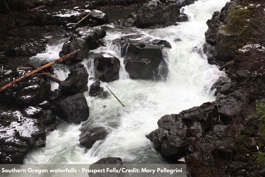
Prospect Waterfalls (Pearsony Falls, Barr Creek Falls, Prospect Falls, Mill Creek Falls; W64): This series of cascades follow the Rogue River just outside the town of Prospect. The river drops and ricochets until it hits a stretch of boulders.
Klamath Falls (W66): Define waterfall? That’s what you might think when you see the falls of Klamath Falls. They’re more of a set of whitewater rapids. And yet, they’re beautiful and worth the short trek.
OREGON COAST WATERFALLS
Youngs River Falls (W1): Grab your bathing suit! This 50-foot waterfall is a popular swimming spot during the summer months.
Hug Point Falls (W3): This waterfall sits at a beach and is surrounded by several caves. Visit at low tide and be sure to get back to the trail head before the tide turns.
Blumenthal Falls (W4): This is one of the few waterfalls in the Northwest that you can see fall into the Pacific Ocean without needing any help from a boat, thank you.
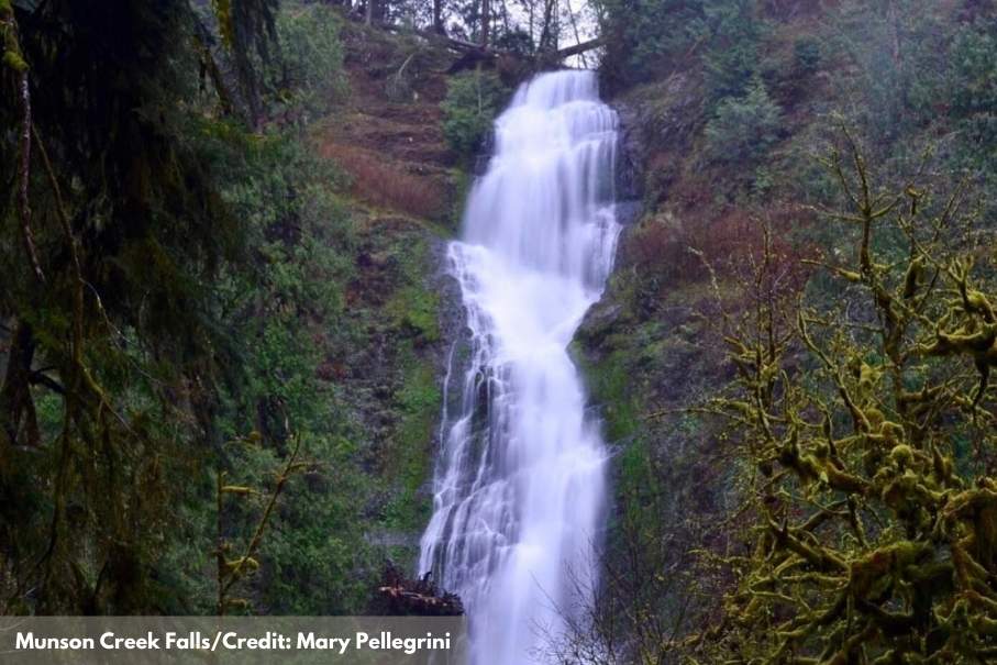
Munson Creek Falls (W28): Whoa! This is the tallest waterfall in the Coast Range — tumbling 319 feet over several tiers. A small trail winds along the Munson Creek through an old-growth forest to find the base of the fall.
Upton Falls (W29): Something fishy? Well, maybe fish-related at least. This fall was the upstream limit of migration for native fish but the falls have been altered to include a fish ladder and a dam to divert the water too.
Drift Creek Falls (W34): The 240-foot suspension bridge (the longest in all of Oregon!) crosses the canyon beside the 8-ft falls, making this waterfall excursion unlike any other.
Rocky Creek Falls (W38): Pull off Highway 101 and you’re likely to see these easy-to-reach and easy-to-spot falls. They spill right into the Pacific Ocean.
Golden Falls (W54): Did you know that if you hike a little over a mile to the top of Golden Falls you can see a bird’s-eye view of the waterfall, firs, and cedars. Golden Falls is the third tallest waterfall in the Oregon Coast Range and share the state natural area with Silver Falls
Elk Creek Falls (W62): It may be last but it’s not least. Elk Creek Falls is the final of about a dozen significant waterfalls situated within the Elk Creek basin.
Secret Beach Falls (W65): Shh… it’s called a secret because it’s hard to find but here’s the skinny. Tucked into the northern-most end where the Oregon Coast Trail squishes between the road and the overlook to Thunder Rock Cove, you’ll find a nearby trail that leads to a small beach with a waterfall.
WILLAMETTE VALLEY WATERFALLS
Beaver Falls (W2): Beaver Falls spills from a lip of basalt into a turquoise-colored pool. Some say that if you come at the right time, you’ll see rainbows in the mist. Beaver Falls is one you can spot from the road if you’d rather not walk the trail.
Willamette Falls (W16): This horseshoe-shaped block waterfall is created by a basalt shelf in the river bottom. It’s fall is 42 ft high and 1,500-ft -wide and set the record for being the largest waterfall by water volume in the Northwest and also for being the 18th largest by volume. Surrounding the falls are the locks, which are the oldest continuously operating multi-lift lock and canal system in all of the United States.
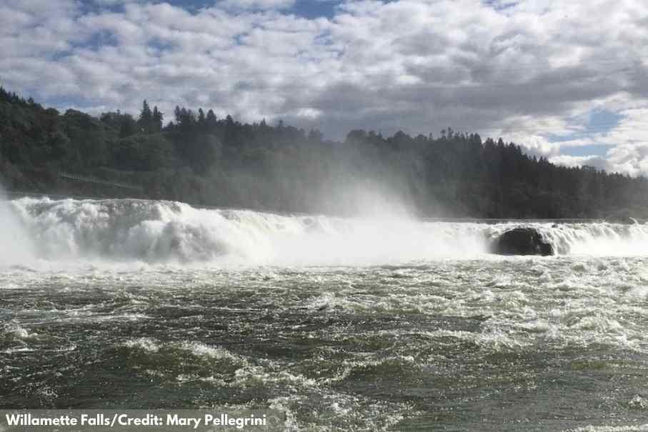
INSIDER TIP! Take a jet boat ride up the Willamette River to the base of the falls.
Niagara Falls (W30) and Pheasant Creek Falls (W31): Follow the foliage then cross not one wooden bridge but FOUR — each with a magnificent view of two 100-ft waterfalls: Niagara Falls and Pheasant Creek Falls.
Scotts Mills Falls (W32): Scotts Mills Falls is a small fall with big popularity. It sits at the site of a former flour mill and cascades through a rocky cliff into the large swimming hole.
Falls City Falls (W35): Falls City Falls are at the center of Falls City. In fact, Falls City is named after the falls. In the past, this was a lumbermill town.
Trail of Ten Falls at Silver Falls State Park (W36): This is Oregon’s largest State Park, coming in at 9,000-acres. It also has one of the most impressive waterfall day-hikes in the United States! Well, there are at least 10 spectacular falls within this 7.8 mile-loop.
Parker Creek Falls (W39): To see Parker Falls you’ll need to work your way through the Parker Falls Trail. The rewards are huge! You’ll see a series of waterfalls, pools and cascades nestled in a forest of Douglas fir.
Parker Creek Falls (W39) and Alder Creek Falls (W40) are roadside on the way up to Mary’s Peak, the highest in Oregon’s Coast Range at 4,097 feet.
Royal Terrace Falls (W43): Royal Terrace Falls is the biggest of the four falls at McDowell Creek Falls Park though it’s also the lowest-volume. A sign nailed to a nearby tree says the falls drop 119 feet.
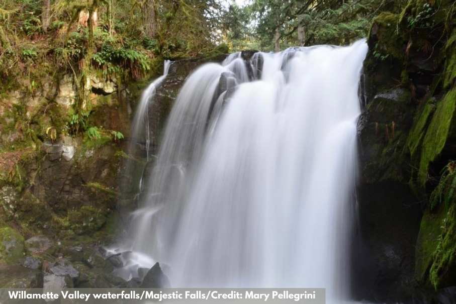
Majestic Falls (W44): This 39-ft waterfall is arguably the most beautiful of McDowell Creek Park. There are staircases with nearly 70 steps that let you explore the cascading waterfall from different vantage points.
Our Chasing Waterfalls and Oregon Waterfall Wednesdays series continues. According to Northwest Waterfall Survey there are well over 1000 waterfalls in Oregon! We’ve set out to witness the beauty of as many as we can. We’ll share our finds with you, our guests, so you too can set out to Chase Waterfalls.
The front of the map features more than 80 must-see waterfalls across the entire state, as well as nearby bed and breakfasts. The back on the map highlights various bits of information, like:
You’ll also find the following informative panels:
- Insta-worthy Drives in Oregon
- Bike-Friendly Lodging in Oregon
- Portland Oregon’s Food Cart Pods
- Native American Food in Oregon
- Oregon Food Trails and Food Loops
- Oregon Wine Country AVAs
- Must-See Oregon Movie Locations
- Oregon Trail History
- Native Heritage
- Oregon Bucket List
Where To Stay. What To Do. Where To Eat. Where To Play. The Oregon Trail Of Waterfalls Map From The Oregon Bed And Breakfast Guild Will Inspire You
Download the Oregon Trail of Waterfall map and start the new year right with some Oregon inspiration. Our Oregon Trail of Waterfalls Map was created with your planning in mind. We included where to stay, things to do in Oregon, where to eat and of course, where to find some of the very best Oregon Waterfalls.
You’ll find a mountain of epic trip ideas for your next outdoor, cultural or culinary adventure in every corner of the state. Now more than two dozen inns are ready to help you plan your most EPIC Oregon road trip!
SEE A DIGITAL VERSION OF THE MAP
Oregon Bed and Breakfast Guild is ready to share Oregon with you: it’s environment, culture, and heritage. Combine gracious hospitality with ambiance at an inspected and approved Oregon Bed and Breakfast Guild member Inn.
Hospitality Update: Our inns are following COVID-19 protocol guidance from the Oregon Health Authority.
Although mask guidelines are lifted:
● Some businesses may choose to still require masks.
● Some people may choose to still wear a mask.
We have all struggled through COVID-19 and could use a little kindness. Please be respectful of local businesses and their workers and most importantly kind to yourself.